![geo5_icon geo5_icon](https://techassist.ae/wp-content/uploads/2023/09/geo5_icon.png)
GEO5
Geotechnical Software
Intuitive software suite for civil engineers and geologists.
![](https://techassist.ae/wp-content/uploads/2023/09/geo5-homepage-2023-spring-en.png)
GEO5 is a comprehensive software suite providing solutions for any task
from geological survey to advanced geotechnical design.
![](https://techassist.ae/wp-content/uploads/2023/09/slope-inv.png)
Stability Analysis
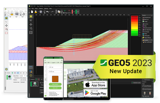
Analysis of slope stability, rock slopes and MSE walls.
![](https://techassist.ae/wp-content/uploads/2023/09/sheeting-inv.png)
Excavation Design
Design and verification of retaining structures, diaphragm and pile walls.
![](https://techassist.ae/wp-content/uploads/2023/09/walls-inv.png)
Retaining Wall Design
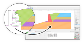
Complex design of gravity, cantilever and prefab retaining walls.
![](https://techassist.ae/wp-content/uploads/2023/09/footing-inv.png)
Shallow Foundations
Bearing capacity and settlement of spread footing, strip footing and foundation mats.
![](https://techassist.ae/wp-content/uploads/2023/09/deep-inv.png)
Pile Foundations
Bearing capacity and settlement of piles and pile groups.
![](https://techassist.ae/wp-content/uploads/2023/09/settlement-inv.png)
Settlement Calculations
Analysis of settlement and consolidation of foundations.
![](https://techassist.ae/wp-content/uploads/2023/09/tunnel-inv.png)
Tunnels and Shafts
Analysis of tunnels, underground structures and vertical shafts
![](https://techassist.ae/wp-content/uploads/2023/09/stratigraphy-inv.png)
Geological Modelling
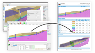
Terrain and subsoil modelling based on geological survey data.
![](https://techassist.ae/wp-content/uploads/2023/09/tests-inv.png)
Geological Survey
Site investigation data (boreholes, CPTs), reporting and creation of cross-sections.
For More Information
Solutions
![](https://techassist.ae/wp-content/uploads/2023/09/intuitive-friendly-1.png)
Intuitive Interface Top-Down Workflow
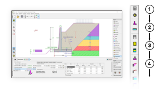
GEO5 programs have unified environment and intuitive interface top-down workflow .
![](https://techassist.ae/wp-content/uploads/2023/09/survey-to-design.png)
From The Survey To The Advanced Design
GEO5 integrates geological data modeling with advanced geotechnical tasks.
![](https://techassist.ae/wp-content/uploads/2023/09/linked-together-1.png)
Program Linked Together
GEO5 enables comparison of two independent solutions.
![](https://techassist.ae/wp-content/uploads/2023/09/geo5-geological-data-collector-app-stratigraphy-site-investigation-mobile.png)
Mobile App For Borehole Logging
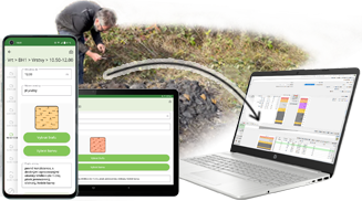
Collect geological data in the field and send it to the stratigraphy program.
![](https://techassist.ae/wp-content/uploads/2023/09/bim.png)
BIM Support
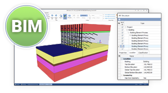
GEO5 is export data to common BIM and share and share with them third party program.
![](https://techassist.ae/wp-content/uploads/2023/09/normy.png)
Many Standard And Method
GEO5 is universal tool for engineers all over the world.
![](https://techassist.ae/wp-content/uploads/2023/09/linked-together-1.png)
Analytical Method & FEM
GEO5 enables to transfer data between individual programs.
![](https://techassist.ae/wp-content/uploads/2023/09/languages.png)
Output Report Language
GEO5 generates output reports in variety of languages- useful for foreign projects.
![](https://techassist.ae/wp-content/uploads/2023/09/reports.png)
Comprehensive Output
GEO5 output reports can be easily edited or exports to PDF or MS Word format.
![](https://techassist.ae/wp-content/uploads/2023/05/Delivery-Service-1-1-1.webp)
Contact Us
Fill in the details & our team will contact you shortly